
Glencullen ED topographic map
Interactive map
Click on the map to display elevation.
About this map
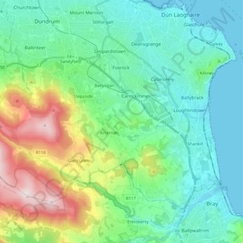
Name: Glencullen ED topographic map, elevation, terrain.
Average elevation: 449 ft
Minimum elevation: 0 ft
Maximum elevation: 1,814 ft
Other topographic maps
Click on a map to view its topography, its elevation and its terrain.
Brennanstown
Brennanstown, Ballybrack ED, Dublin 18, Dún Laoghaire-Rathdown, County Dublin, Leinster, Ireland
Average elevation: 203 ft
Carrickmines Great
Carrickmines Great, Cabinteely-Loughlinstown ED, Dublin 18, Dún Laoghaire-Rathdown, County Dublin, Leinster, Ireland
Average elevation: 312 ft