
Thank you for supporting this site ❤️
Make a donation
Make a donation
Gear up for your next adventure:
As an Amazon Associate, this site earns from qualifying purchases at no extra cost to you.
Eberbach topographic map
Click on the map to display elevation.
Thank you for supporting this site ❤️
Make a donation
Make a donation
Gear up for your next adventure:
As an Amazon Associate, this site earns from qualifying purchases at no extra cost to you.
Eberbach
Eberbach lies at the foot of the Katzenbuckel, at 626 m the highest elevation in the Odenwald, in the Naturpark Neckartal-Odenwald, on the romantic Burgenstraße (Castle Road) along the river Neckar.
Thank you for supporting this site ❤️
Make a donation
Make a donation
Gear up for your next adventure:
As an Amazon Associate, this site earns from qualifying purchases at no extra cost to you.
About this map
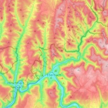
Name: Eberbach topographic map, elevation, terrain.
Average elevation: 1,220 ft
Minimum elevation: 377 ft
Maximum elevation: 2,014 ft
Thank you for supporting this site ❤️
Make a donation
Make a donation
Gear up for your next adventure:
As an Amazon Associate, this site earns from qualifying purchases at no extra cost to you.