
Reedy Creek Improvement District topographic map
Interactive map
Click on the map to display elevation.
About this map
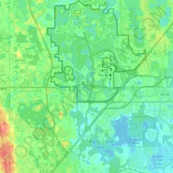
Name: Reedy Creek Improvement District topographic map, elevation, terrain.
Average elevation: 102 ft
Minimum elevation: 56 ft
Maximum elevation: 230 ft
Other topographic maps
Click on a map to view its topography, its elevation and its terrain.
St. Augustine
United States of America > Florida > St. Augustine
St. Augustine, St. Johns County, Florida, 32084, United States of America
Average elevation: 16 ft
Brandon
United States of America > Florida > Brandon
Brandon, Hillsborough County, Florida, 33511-5421, United States of America
Average elevation: 62 ft
The Villages
United States of America > Florida > The Villages
The Villages, Lake County, Florida, 34499, United States of America
Average elevation: 79 ft
Crestview
United States of America > Florida > Crestview
Crestview, Okaloosa County, Florida, 32536, United States of America
Average elevation: 174 ft
Lake Placid
United States of America > Florida
Lake Placid, Lighthouse Point, Broward County, Florida, 33062, United States of America
Average elevation: 10 ft
West Palm Beach
United States of America > Florida > West Palm Beach
West Palm Beach, Palm Beach County, Florida, 33401, United States of America
Average elevation: 13 ft
Lehigh Acres
United States of America > Florida > Presbyterian Villas Of Lehigh
Lehigh Acres, Kingsbury Street East, Lehigh Acres, Presbyterian Villas Of Lehigh, Lee County, Florida, 33974, United States of America
Average elevation: 30 ft
Oakland Park
United States of America > Florida > Oakland Park
Oakland Park, Broward County, Florida, United States of America
Average elevation: 20 ft
Bayonet Point
United States of America > Florida > Bayonet Point
Bayonet Point, Lora del Rio Drive, Bayonet Point, Pasco County, Florida, 34668, United States of America
Average elevation: 26 ft
St. Cloud
United States of America > Florida > St. Cloud
St. Cloud, Osceola County, Florida, 34769-3339, United States of America
Average elevation: 69 ft
Butler Beach
United States of America > Florida
Butler Beach, St. Johns County, Florida, United States of America
Average elevation: 10 ft
West Little River
United States of America > Florida > Miami
West Little River, Northwest 17th Avenue, Miami, Miami-Dade County, Florida, 33054, United States of America
Average elevation: 23 ft
South Sarasota
United States of America > Florida > South Sarasota
South Sarasota, Sarasota County, Florida, United States of America
Average elevation: 20 ft
Bronson
United States of America > Florida > Bronson
Bronson, Levy County, Florida, 32621, United States of America
Average elevation: 69 ft
Cypress Cove Villas
United States of America > Florida > Cypress Cove Villas
Cypress Cove Villas, Lee County, Florida, 33908, United States of America
Average elevation: 10 ft
Kensington
United States of America > Florida > Jacksonville > Kensington
Kensington, Jacksonville, Duval County, Florida, 32246, United States of America
Average elevation: 33 ft
Zion Hill
United States of America > Florida > Tallahassee > Zion Hill
Zion Hill, Tallahassee, Leon County, Florida, 32303-4441, United States of America
Average elevation: 167 ft
Lake Hamilton
United States of America > Florida > Lake Hamilton
Lake Hamilton, Polk County, Florida, United States of America
Average elevation: 141 ft
Spring Lake
United States of America > Florida
Spring Lake, Spring Lake Drive, Lake County, Florida, 34755, United States of America
Average elevation: 112 ft
Lake Ashby
United States of America > Florida > Alamana
Lake Ashby, Madison Avenue, Alamana, Volusia County, Florida, 32168, United States of America
Average elevation: 20 ft
Rio Vista Isles
United States of America > Florida > Fort Lauderdale > Rio Vista Isles
Rio Vista Isles, Fort Lauderdale, Broward County, Florida, 33316, United States of America
Average elevation: 20 ft
Westville
United States of America > Florida > Westville
Westville, Holmes County, Florida, United States of America
Average elevation: 59 ft
Jensen Beach
United States of America > Florida > Jensen Beach > Sewall's Point > Jensen Beach
Jensen Beach, North Sewall's Point Road, Sewall's Point, Martin County, Florida, 34996, United States of America
Average elevation: 16 ft
Anastasia
United States of America > Florida > St. Augustine > Anastasia
Anastasia, St. Augustine, St. Johns County, Florida, 32084, United States of America
Average elevation: 7 ft
Lafayette
United States of America > Florida > Tallahassee > Lafayette
Lafayette, Tallahassee, Leon County, Florida, 32311-3810, United States of America
Average elevation: 148 ft
Grayvik
United States of America > Florida > Grayvik
Grayvik, Monroe, Florida, United States of America
Average elevation: 7 ft
Boca Del Mar
United States of America > Florida
Boca Del Mar, Palm Beach County, Florida, 33433, United States of America
Average elevation: 26 ft
New Pass
United States of America > Florida
New Pass, Sarasota County, Florida, 34236, United States of America
Average elevation: 3 ft
Haven Park
United States of America > Florida > Haven Park
Haven Park, Escambia County, Florida, 32506, United States of America
Average elevation: 7 ft
Pheonix Canal
United States of America > Florida > Cape Coral
Pheonix Canal, Cape Coral, Lee County, Florida, 33904, United States of America
Average elevation: 7 ft
Caravel Park
United States of America > Florida
Caravel Park, North Lauderdale, Broward County, Florida, 33319:33321, United States of America
Average elevation: 20 ft
Lake Fannie
United States of America > Florida > Poinsettia Park
Lake Fannie, Country Club Road North, Poinsettia Park, Polk County, Florida, 33881, United States of America
Average elevation: 128 ft
Bascom
United States of America > Florida
Bascom, Jackson County, Florida, United States of America
Average elevation: 141 ft
Port Charlotte
United States of America > Florida > Port Charlotte > Port Charlotte
Port Charlotte, Charlotte County, Florida, 33952-9046, United States of America
Average elevation: 20 ft
Ballard Pines
United States of America > Florida > Barefoot Bay > Ballard Pines
Ballard Pines, Barefoot Bay, Brevard County, Florida, United States of America
Average elevation: 3 ft
Lake Newman
United States of America > Florida > Jacksonville
Lake Newman, Lake Newman Street, Jacksonville, Duval County, Florida, 32215, United States of America
Average elevation: 79 ft
Rovell Mobile Home Park
United States of America > Florida > Rovell Mobile Home Park
Rovell Mobile Home Park, Miami-Dade County, Florida, 33150, United States of America
Average elevation: 26 ft
Flagami
United States of America > Florida > Flagami
Flagami, Miami-Dade County, Florida, 33144, United States of America
Average elevation: 23 ft
Sand Pond
United States of America > Florida > Crystal Lake > Greenhead
Sand Pond, Rolling Pines Road, Greenhead, Crystal Lake, Washington County, Florida, United States of America
Average elevation: 92 ft
Anchor Mobile Home Park
United States of America > Florida > Anchor Mobile Home Park
Anchor Mobile Home Park, Hialeah, Miami-Dade County, Florida, 33012:33166, United States of America
Average elevation: 20 ft
Saint Cloud
United States of America > Florida > Saint Cloud
Saint Cloud, Osceola County, Florida, United States of America
Average elevation: 574 ft
Miakka
United States of America > Florida > Miakka
Miakka, Sarasota County, Florida, United States of America
Average elevation: 49 ft
Royal Palm Pointe Park
United States of America > Florida > Vero Beach > Riomar
Royal Palm Pointe Park, Royal Palm Pointe, Riomar, Vero Beach, Indian River County, Florida, United States of America
Average elevation: 13 ft
Fern Creek
United States of America > Florida > Orlando
Fern Creek, Orlando, Orange County, Florida, 32803-4806, United States of America
Average elevation: 112 ft
North Lake Village
United States of America > Florida > Miromar Lakes > North Lake Village
North Lake Village, Miromar Lakes, Lee County, Florida, 33965-6565, United States of America
Average elevation: 26 ft
Stockade
United States of America > Florida > Jacksonville > Stockade
Stockade, Jacksonville, Duval County, Florida, 32256, United States of America
Average elevation: 39 ft
Palm Springs
United States of America > Florida > Palm Springs
Palm Springs, Palm Beach County, Florida, United States of America
Average elevation: 30 ft
Highpoint
United States of America > Florida > Highpoint
Highpoint, Pinellas County, Florida, 33760, United States of America
Average elevation: 20 ft
Bassville Park
United States of America > Florida > Bassville Park
Bassville Park, Lake County, Florida, 34788, United States of America
Average elevation: 75 ft
Nashua
United States of America > Florida > Nashua
Nashua, Putnam County, Florida, 32193, United States of America
Average elevation: 56 ft