
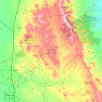
Cerro de San Pedro topographic map
Interactive map
Click on the map to display elevation.
About this map
Name: Cerro de San Pedro topographic map, elevation, terrain.
Location: Cerro de San Pedro, San Luis Potosí, México (22.14141 -100.88432 22.26023 -100.70684)
Average elevation: 6,644 ft
Minimum elevation: 5,574 ft
Maximum elevation: 7,956 ft
Other topographic maps
Click on a map to view its topography, its elevation and its terrain.
Monte Caldera
México > San Luis Potosí > Cerro de San Pedro
Monte Caldera, Cerro de San Pedro, San Luis Potosí, México
Average elevation: 7,126 ft