
Le Baillod topographic map
Interactive map
Click on the map to display elevation.
About this map
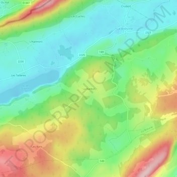
Name: Le Baillod topographic map, elevation, terrain.
Location: Le Baillod, La Brévine, Neuchâtel, 2406, Suisse (46.94658 6.57509 46.98658 6.61509)
Average elevation: 3,671 ft
Minimum elevation: 3,383 ft
Maximum elevation: 4,154 ft
Other topographic maps
Click on a map to view its topography, its elevation and its terrain.
Les Taillères
Suisse > Neuchâtel > La Brévine
Les Taillères, La Brévine, Neuchâtel, 2406, Suisse
Average elevation: 3,609 ft