
Kotdwar topographic map
Click on the map to display elevation.
Kotdwar
Kotdwar lies on the western margin of the Himalayas, at an altitude of 454 m (1,490 ft) above sea level.
About this map
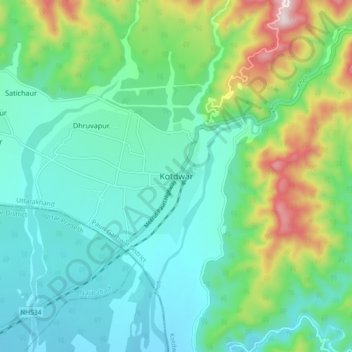
Name: Kotdwar topographic map, elevation, terrain.
Location: Kotdwar, Kotdwara, Pauri Garhwal, Uttarakhand, 246149, India (29.70598 78.48014 29.78598 78.56014)
Average elevation: 1,545 ft
Minimum elevation: 1,063 ft
Maximum elevation: 2,986 ft
Other topographic maps
Click on a map to view its topography, its elevation and its terrain.
Ramganga Dam
India > Uttarakhand > Kotdwara
The dam is a 128 m (420 ft) tall and 630 m (2,067 ft) long earth and rock-fill embankment dam with 10,000,000 m3 (13,079,506 cu yd) of fill. The dam's spillway is controlled by five gates and has a maximum discharge of 8,467 m3/s (299,009 cu ft/s). To support the reservoir's elevation, there is a 72 m (236 ft)…
Average elevation: 1,276 ft