
Libramont-Chevigny topographic map
Interactive map
Click on the map to display elevation.
About this map
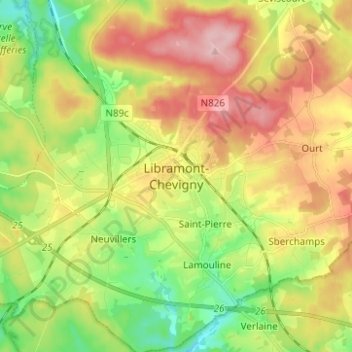
Name: Libramont-Chevigny topographic map, elevation, terrain.
Average elevation: 1,588 ft
Minimum elevation: 1,335 ft
Maximum elevation: 1,883 ft
Other topographic maps
Click on a map to view its topography, its elevation and its terrain.
Libramont
Belgique > Luxembourg > Neufchâteau > Libramont
Libramont, Libramont-Chevigny, Neufchâteau, Luxembourg, Wallonie, Belgique
Average elevation: 1,644 ft