Geolocate

Victoria topographic map

Click on the map to display elevation.

About this map

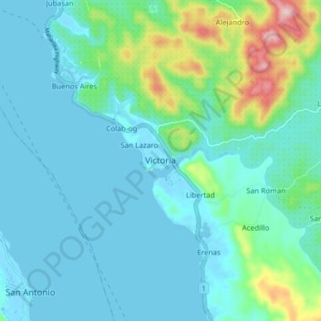
Name: Victoria topographic map, elevation, terrain.

Location: Victoria, Northern Samar, Eastern Visayas, 6406, Philippines (12.40667 124.27235 12.48667 124.35235)

Average elevation: 141 ft

Minimum elevation: -13 ft

Maximum elevation: 791 ft

Other topographic maps

Click on a map to view its topography, its elevation and its terrain.

Tarnate

Philippines > Northern Samar > San Vicente

Average elevation: 92 ft

Pambujan River

Philippines > Northern Samar

Average elevation: 180 ft

Gear up for your next adventure:

🔥Camping Stove - Portable stove for camping and backcountry cooking
🔭Telescopic Hiking Pole - Adjustable pole for hiking stability
📌Outdoor GPS Map App - Apps and devices for digital topographic navigation
🧭Outdoor Navigation Book - Learn advanced navigation skills
🔌USB Car Charger - Car charger for on‑the‑go power needs

As an Amazon Associate, this site earns from qualifying purchases at no extra cost to you.