
Whataroa River topographic map
Interactive map
Click on the map to display elevation.
About this map
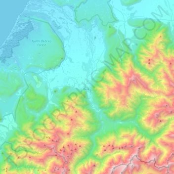
Name: Whataroa River topographic map, elevation, terrain.
Location: Whataroa River, Westland District, West Coast, New Zealand (-43.44538 170.24781 -43.11667 170.44456)
Average elevation: 2,054 ft
Minimum elevation: -7 ft
Maximum elevation: 8,373 ft
Other topographic maps
Click on a map to view its topography, its elevation and its terrain.
Douglas Pass
New Zealand > West Coast > Westland District
Douglas Pass, Westland District, West Coast, New Zealand
Average elevation: 5,259 ft
Lake Windermere
New Zealand > West Coast > Westland District
Lake Windermere, Westland District, West Coast, New Zealand
Average elevation: 13 ft
Katau Knob
New Zealand > West Coast > Westland District
Katau Knob, Westland District, West Coast, New Zealand
Average elevation: 2,710 ft
Snowden
New Zealand > West Coast > Westland District
Snowden, Westland District, West Coast, New Zealand
Average elevation: 3,442 ft
Mt Wilson
New Zealand > West Coast > Westland District
Mt Wilson, Westland District, West Coast, New Zealand
Average elevation: 3,694 ft
Ōkārito
New Zealand > West Coast > Westland District
Ōkārito, Westland District, West Coast, New Zealand
Average elevation: 82 ft