
Kisteleki járás topographic map
Interactive map
Click on the map to display elevation.
About this map
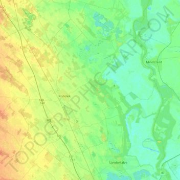
Name: Kisteleki járás topographic map, elevation, terrain.
Average elevation: 282 ft
Minimum elevation: 243 ft
Maximum elevation: 348 ft
Other topographic maps
Click on a map to view its topography, its elevation and its terrain.
Tschongrad
Ungarn > Komitat Tschongrad-Tschanad
Tschongrad, Kreis Tschongrad, Komitat Tschongrad-Tschanad, Südliche Tiefebene, Nördliche Große Tiefebene, Ungarn
Average elevation: 269 ft
Csengele
Ungarn > Komitat Tschongrad-Tschanad
Csengele, Kisteleki járás, Komitat Tschongrad-Tschanad, Südliche Tiefebene, Nördliche Große Tiefebene, 6765, Ungarn
Average elevation: 312 ft