
La Chinantla topographic map
Interactive map
Click on the map to display elevation.
About this map
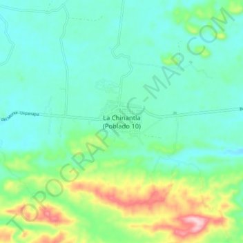
Name: La Chinantla topographic map, elevation, terrain.
Location: La Chinantla, Uxpanapa, Veracruz, México (17.25623 -94.47136 17.29623 -94.43136)
Average elevation: 384 ft
Minimum elevation: 253 ft
Maximum elevation: 735 ft
Other topographic maps
Click on a map to view its topography, its elevation and its terrain.
Benito Juárez Segundo (La Raya)
Benito Juárez Segundo (La Raya), Uxpanapa, Veracruz, México
Average elevation: 285 ft
Poblado Cinco
Poblado Cinco, Uxpanapa, Veracruz, México
Average elevation: 318 ft
Isthmus of Tehuantepec
Isthmus of Tehuantepec, Uxpanapa, Veracruz, México
Average elevation: 909 ft