
Link Island topographic map
Interactive map
Click on the map to display elevation.
About this map
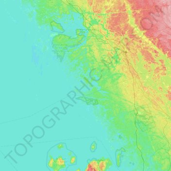
Name: Link Island topographic map, elevation, terrain.
Average elevation: 663 ft
Minimum elevation: 561 ft
Maximum elevation: 1,119 ft
Other topographic maps
Click on a map to view its topography, its elevation and its terrain.
Blackstone Harbour (Massasauga Wildlands) Provincial Park
Canada > Ontario > The Archipelago
Blackstone Harbour (Massasauga Wildlands) Provincial Park, The Archipelago, Parry Sound District, Ontario, Canada
Average elevation: 607 ft