
Beauvais topographic map
Interactive map
Click on the map to display elevation.
About this map
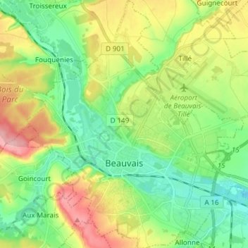
Name: Beauvais topographic map, elevation, terrain.
Average elevation: 325 ft
Minimum elevation: 167 ft
Maximum elevation: 597 ft
Die Kathedrale Saint-Pierre, eines der bedeutendsten Bauwerke der Gotik, besteht aus einem Querschiff und einem Chor mit Apsis sowie sieben Apsidenkapellen. Die Säulen im Inneren erheben sich bis in 30 Meter Höhe, der Chor selbst ist mit 48,50 Metern der höchste gotische der Welt.
Other topographic maps
Click on a map to view its topography, its elevation and its terrain.
Rantigny
Frankreich > Nordfrankreich > Oise
Rantigny, Clermont, Oise, Nordfrankreich, Metropolitanes Frankreich, 60290, Frankreich
Average elevation: 194 ft
Lieu-dit Vallée de Gournay
Frankreich > Nordfrankreich > Oise > Haucourt
Lieu-dit Vallée de Gournay, Haucourt, Beauvais, Oise, Nordfrankreich, Metropolitanes Frankreich, 60112, Frankreich
Average elevation: 427 ft
Courcelles-lès-Gisors
Frankreich > Nordfrankreich > Oise
Courcelles-lès-Gisors, Beauvais, Oise, Nordfrankreich, Metropolitanes Frankreich, 60240, Frankreich
Average elevation: 246 ft