
Quindous topographic map
Interactive map
Click on the map to display elevation.
About this map
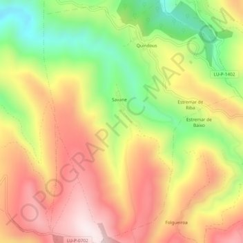
Name: Quindous topographic map, elevation, terrain.
Location: Quindous, Cervantes, Os Ancares, Lugo, Galiza, 27662, Espanha (42.83733 -7.01077 42.87153 -6.97379)
Average elevation: 2,953 ft
Minimum elevation: 1,886 ft
Maximum elevation: 3,898 ft
Other topographic maps
Click on a map to view its topography, its elevation and its terrain.
Tesón
Espanha > Galiza > Os Ancares > Cervantes
Tesón, Cervantes, Os Ancares, Lugo, Galiza, 27667, Espanha
Average elevation: 3,894 ft