
Harles topographic map
Interactive map
Click on the map to display elevation.
About this map
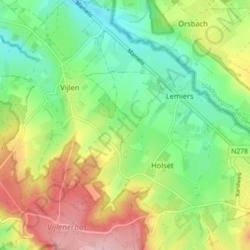
Name: Harles topographic map, elevation, terrain.
Location: Harles, Vijlen, Vaals, Limburg, Nederland, 6294 NG, Nederland (50.76162 5.95838 50.80162 5.99838)
Average elevation: 636 ft
Minimum elevation: 410 ft
Maximum elevation: 971 ft
Other topographic maps
Click on a map to view its topography, its elevation and its terrain.