
Adalikhal topographic map
Interactive map
Click on the map to display elevation.
About this map
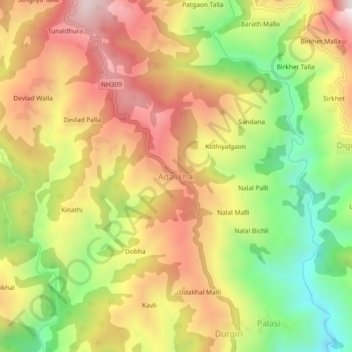
Name: Adalikhal topographic map, elevation, terrain.
Average elevation: 4,386 ft
Minimum elevation: 3,015 ft
Maximum elevation: 5,659 ft
Other topographic maps
Click on a map to view its topography, its elevation and its terrain.
Chorgadh Malla
India > Uttarakhand > Dhoomakot > Patotidanda
Chorgadh Malla, Patotidanda, Dhoomakot, Pauri Garhwal District, Uttarakhand, 246277, India
Average elevation: 4,518 ft
Haldukhal
India > Uttarakhand > Dhoomakot > Haldukhal
Haldukhal, Dhoomakot, Pauri Garhwal, Uttarakhand, 246161, India
Average elevation: 3,550 ft
Ugliyatanda
India > Uttarakhand > Dhoomakot > Nainidhara > Ugliyatanda
Ugliyatanda, Nainidhara, Dhoomakot, Pauri Garhwal, Uttarakhand, 246161, India
Average elevation: 4,636 ft