
Djebel Sidi Mansour topographic map
Interactive map
Click on the map to display elevation.
About this map
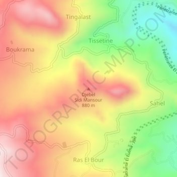
Name: Djebel Sidi Mansour topographic map, elevation, terrain.
Average elevation: 2,257 ft
Minimum elevation: 1,188 ft
Maximum elevation: 3,169 ft
Other topographic maps
Click on a map to view its topography, its elevation and its terrain.
Ras El Bour
Algérie > Jijel > Daïra Djimla > Boudria Ben Yadjis
Ras El Bour, Boudria Ben Yadjis, Daïra Djimla, Jijel, Algérie
Average elevation: 2,421 ft
Tamra
Algérie > Jijel > Daïra Djimla > Boudria Ben Yadjis
Tamra, Boudria Ben Yadjis, Daïra Djimla, Jijel, Algérie
Average elevation: 1,696 ft