
Baie des Homards topographic map
Interactive map
Click on the map to display elevation.
About this map
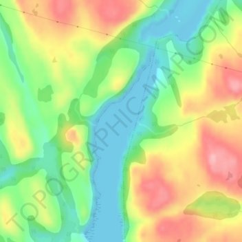
Name: Baie des Homards topographic map, elevation, terrain.
Average elevation: 180 ft
Minimum elevation: 0 ft
Maximum elevation: 404 ft
Other topographic maps
Click on a map to view its topography, its elevation and its terrain.
Côte-Nord-du-Golfe-du-Saint-Laurent
Canada > Québec > Le Golfe-du-Saint-Laurent
Côte-Nord-du-Golfe-du-Saint-Laurent, Le Golfe-du-Saint-Laurent, Côte-Nord, Québec, Canada
Average elevation: 554 ft
Pakuashipi
Canada > Québec > Le Golfe-du-Saint-Laurent > Saint-Augustin
Pakuashipi, Saint-Augustin, Le Golfe-du-Saint-Laurent, Côte-Nord, Québec, Canada
Average elevation: 210 ft
Lac Long Pond
Canada > Québec > Le Golfe-du-Saint-Laurent > Bonne-Espérance
Lac Long Pond, Bonne-Espérance, Le Golfe-du-Saint-Laurent, Côte-Nord, Québec, Canada
Average elevation: 361 ft
Blanc-Sablon
Canada > Québec > Le Golfe-du-Saint-Laurent
Blanc-Sablon, Le Golfe-du-Saint-Laurent, Côte-Nord, Québec, Canada
Average elevation: 322 ft
Kegaska
Canada > Québec > Le Golfe-du-Saint-Laurent > Côte-Nord-du-Golfe-du-Saint-Laurent
Kegaska, Côte-Nord-du-Golfe-du-Saint-Laurent, Le Golfe-du-Saint-Laurent, Côte-Nord, Québec, Canada
Average elevation: 20 ft