
Bouldoux topographic map
Interactive map
Click on the map to display elevation.
About this map
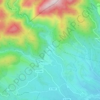
Name: Bouldoux topographic map, elevation, terrain.
Average elevation: 932 ft
Minimum elevation: 407 ft
Maximum elevation: 2,221 ft
Other topographic maps
Click on a map to view its topography, its elevation and its terrain.
Les Baumelles
France > Occitanie > Hérault > Babeau-Bouldoux
Les Baumelles, Babeau-Bouldoux, Béziers, Hérault, Occitanie, France métropolitaine, 34360, France
Average elevation: 1,447 ft
Babeau
France > Occitanie > Hérault > Babeau-Bouldoux
Babeau, Babeau-Bouldoux, Béziers, Hérault, Occitanie, France métropolitaine, 34360, France
Average elevation: 846 ft