
Make a donation
Gear up for your next adventure:
As an Amazon Associate, this site earns from qualifying purchases at no extra cost to you.
Schannenbach topographic map
Click on the map to display elevation.
Make a donation
Gear up for your next adventure:
As an Amazon Associate, this site earns from qualifying purchases at no extra cost to you.
Schannenbach
Die Statistisch-topographisch-historische Beschreibung des Großherzogthums Hessen berichtet 1829 über Schannenbach.
Make a donation
Gear up for your next adventure:
As an Amazon Associate, this site earns from qualifying purchases at no extra cost to you.
About this map
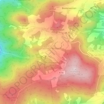
Name: Schannenbach topographic map, elevation, terrain.
Location: Schannenbach, Lautertal, Kreis Bergstraße, Hessen, Deutschland (49.68581 8.71966 49.69122 8.72556)
Average elevation: 1,522 ft
Minimum elevation: 899 ft
Maximum elevation: 1,909 ft
Make a donation
Gear up for your next adventure:
As an Amazon Associate, this site earns from qualifying purchases at no extra cost to you.