
Thank you for supporting this site ❤️
Make a donation
Make a donation
Gear up for your next adventure:
As an Amazon Associate, this site earns from qualifying purchases at no extra cost to you.
Benquerença topographic map
Click on the map to display elevation.
Thank you for supporting this site ❤️
Make a donation
Make a donation
Gear up for your next adventure:
As an Amazon Associate, this site earns from qualifying purchases at no extra cost to you.
About this map
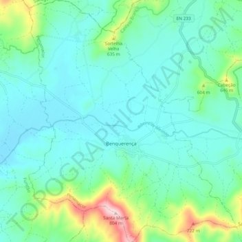
Name: Benquerença topographic map, elevation, terrain.
Location: Benquerença, Penamacor, Castelo Branco, Portugal (40.19642 -7.27340 40.26791 -7.19320)
Average elevation: 1,703 ft
Minimum elevation: 1,470 ft
Maximum elevation: 2,631 ft
Thank you for supporting this site ❤️
Make a donation
Make a donation
Gear up for your next adventure:
As an Amazon Associate, this site earns from qualifying purchases at no extra cost to you.