Geolocate

Mount Semeru topographic map

Click on the map to display elevation.

About this map

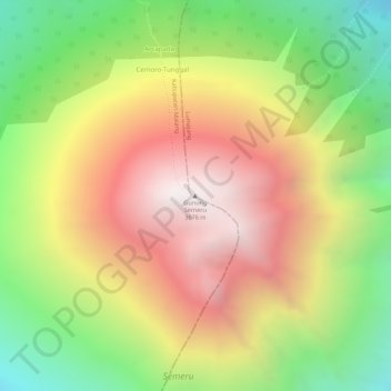
Name: Mount Semeru topographic map, elevation, terrain.

Location: Mount Semeru, Lumajang, East Java, Java, Indonesia (-8.10789 112.92243 -8.10779 112.92253)

Average elevation: 10,180 ft

Minimum elevation: 8,143 ft

Maximum elevation: 12,008 ft

Gear up for your next adventure:

🔌Solar Panel Charger - Charge gear sustainably outdoors
👟Trail Running Shoes - Lightweight shoes for trail runners
🎒Hydration Pack - Hands‑free water reservoir for long hikes
🍳Camping Cook Set - Complete cookware for outdoor meals
🌲Outdoor Survival Books - Best books on survival skills

As an Amazon Associate, this site earns from qualifying purchases at no extra cost to you.