
Make a donation
Gear up for your next adventure:
As an Amazon Associate, this site earns from qualifying purchases at no extra cost to you.
Isla Milne Edwards topographic map
Click on the map to display elevation.
Make a donation
Gear up for your next adventure:
As an Amazon Associate, this site earns from qualifying purchases at no extra cost to you.
About this map
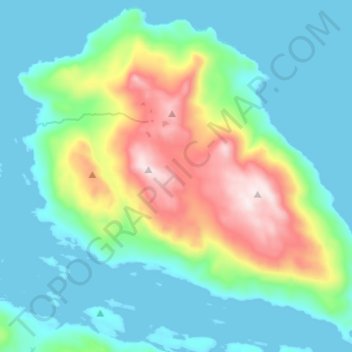
Name: Isla Milne Edwards topographic map, elevation, terrain.
Average elevation: 489 ft
Minimum elevation: -3 ft
Maximum elevation: 2,018 ft
Make a donation
Gear up for your next adventure:
As an Amazon Associate, this site earns from qualifying purchases at no extra cost to you.
Other topographic maps
Click on a map to view its topography, its elevation and its terrain.
Chair
Chile > Region of Magallanes and Chilean Antarctica > Provincia de la Antártica Chilena > Cape Horn
Average elevation: 59 ft
Co. Santiago Benadava
Chile > Region of Magallanes and Chilean Antarctica > Provincia de la Antártica Chilena > Cape Horn
Average elevation: 3,045 ft