
Tulagi topographic map
Interactive map
Click on the map to display elevation.
About this map
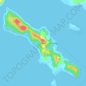
Name: Tulagi topographic map, elevation, terrain.
Location: Tulagi, Central Province, Solomon Islands (-9.11277 160.13376 -9.09032 160.15873)
Average elevation: 20 ft
Minimum elevation: -7 ft
Maximum elevation: 226 ft
Other topographic maps
Click on a map to view its topography, its elevation and its terrain.
Tulagi
Solomon Islands > Central Province > Tulagi
Tulagi, Central Province, Solomon Islands
Average elevation: 92 ft