
Silver Point topographic map
Click on the map to display elevation.
About this map
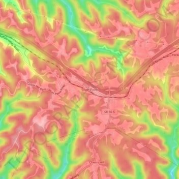
Name: Silver Point topographic map, elevation, terrain.
Average elevation: 955 ft
Minimum elevation: 656 ft
Maximum elevation: 1,076 ft
Putnam County trails, hiking, mountain biking, running and outdoor activities
Other topographic maps
Click on a map to view its topography, its elevation and its terrain.
Cookeville
United States > Tennessee > Putnam County
Located on the Highland Rim, Cookeville's elevation (1100 ft AMSL) is a few hundred feet higher than either Nashville or Knoxville. As a result, temperatures and humidity levels are generally slightly lower in Cookeville than in either the Nashville Basin or in the Tennessee Valley.
Average elevation: 1,089 ft
Window Cliffs State Natural Area
United States > Tennessee > Putnam County > Hillrose
Average elevation: 928 ft
Cookeville
United States > Tennessee > Putnam County
Located on the Highland Rim, Cookeville's elevation (1100 ft AMSL) is a few hundred feet higher than either Nashville or Knoxville. As a result, temperatures and humidity levels are generally slightly lower in Cookeville than in either the Nashville Basin or in the Tennessee Valley.
Average elevation: 1,089 ft
Cookeville
United States > Tennessee > Putnam County
Located on the Highland Rim, Cookeville's elevation (1100 ft AMSL) is a few hundred feet higher than Nashville's or Knoxville's. As a result, temperatures and humidity levels are generally slightly lower in Cookeville than in either the Nashville Basin or the Tennessee Valley.
Average elevation: 1,089 ft
Chelsea Place Duck Pond
United States > Tennessee > Putnam County > Cookeville > Bilbrey Park
Average elevation: 1,119 ft