
Make a donation
Gear up for your next adventure:
As an Amazon Associate, this site earns from qualifying purchases at no extra cost to you.
Mount Blue Sky topographic map
Click on the map to display elevation.
Make a donation
Gear up for your next adventure:
As an Amazon Associate, this site earns from qualifying purchases at no extra cost to you.
Mount Blue Sky
The history of the Mount Evans Scenic Byway is part of a larger story of the Denver Mountain Parks system. The City and County of Denver initiated the construction of a series of automobile "scenic loops" to allow Denverites to explore the mountains. One road circuit, Circle G, was to traverse the ridge to Mestaa'ėhehe Pass on to Echo Lake, culminate in a climb up Mount Blue Sky, and loop down to Idaho Springs. In order to achieve this goal, Denver Mountain Parks acquired a series of land parcels, including the acquisition of Bergen Park in 1915. The Bear Creek segment from the Genesee saddle to Bergen Park was finished in 1915, while the Denver Mountain Parks committee worked to make Mount Evans a National Park, going as far as getting support in Congress for the construction of a "cement road" to the mountain. The first mile was paid for by Denver with the understanding that the State Highway Commission would do the rest. The Denver Mountain Parks committee was not without disagreement and setbacks, however. $30,000 was acquired early in 1916 to construct the Bergen Park to Mestaa'ėhehe Pass segment and all seemed to be flowing towards the goal of Mount Evans when the mayor of Denver, Robert W. Speer, appointed W.F.R. Mills as the Commissioner of Improvements, who summarily stopped the construction of the road, stating that "It is a road that starts nowhere, ends nowhere, and never gets there". After studying the issue, Mills later recanted and became a supporter of the park system, and the segment between Bergen Park and Mestaa'ėhehe Pass was constructed beginning in the spring of 1918. The next act was to get Mount Evans classified as a National Park, but 1916 was a tumultuous time between the National Park system and the U.S. Forest Service, who currently held claim to the mountain. Already in bitter struggle to prevent the formation of a National Park Service, Chief Forester Graves adamantly blocked the relinquishment of this area of National Forest, in exchange for Forest Service development of the area including the immediate construction of a road between Mestaa'ėhehe Pass and Echo Lake (Colorado). This joint exercise between the City and County of Denver, the U.S. Congress, the State Highway System, and now the Forest Service would be completed with help of a newly formed Federal Agency, the Bureau of Public Roads. In 1918, the Bureau of Public Roads provided the plan to construct 9.41 miles of road from Soda Pass (later called Squaw Pass and now called Mestaa'ėhehe Pass) to Echo Lake beginning in 1919. By 1920, the road had only managed to be constructed to Chief Mountain. By October 1 of 1921, the Bureau of Public Roads had completed construction to Echo Lake. The first survey for the road from Echo Lake to the peak of Mount Blue Sky was made in 1923, finishing the layout by January 1924 despite a flu outbreak in the camp, damaging windstorms, and nearly insurmountable environmental hardships. Battling the unusual problems that come with high-altitude construction (steam shovels performing only half as effective at high altitude, difficulty of hauling coal and water, horse suicide, etc.) the last 600 feet were finally built by hand, being completed in 1930.
Make a donation
Gear up for your next adventure:
As an Amazon Associate, this site earns from qualifying purchases at no extra cost to you.
About this map
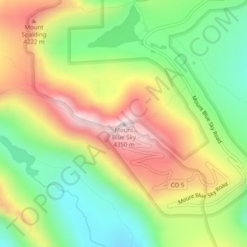
Name: Mount Blue Sky topographic map, elevation, terrain.
Average elevation: 13,143 ft
Minimum elevation: 12,260 ft
Maximum elevation: 14,239 ft
Clear Creek County trails, hiking, mountain biking, running and outdoor activities
Make a donation
Gear up for your next adventure:
As an Amazon Associate, this site earns from qualifying purchases at no extra cost to you.
Other topographic maps
Click on a map to view its topography, its elevation and its terrain.
Make a donation
Gear up for your next adventure:
As an Amazon Associate, this site earns from qualifying purchases at no extra cost to you.
Georgetown
United States > Colorado > Clear Creek County
The town sits at an elevation of 8,530 feet (2,600 m) above sea level, nestled in the mountains near the upper end of the valley of Clear Creek in the mountains west of Denver along Interstate 70. Although population was only about 1,000 at the 2010 census, the town was a historic center of the mining industry…
Average elevation: 9,757 ft