Geolocate

Peterlee topographic map

Click on the map to display elevation.

About this map

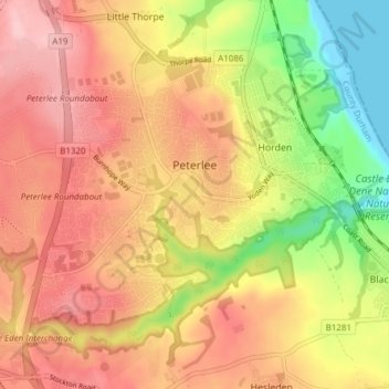
Name: Peterlee topographic map, elevation, terrain.

Location: Peterlee, County Durham, North East, England, United Kingdom (54.74145 -1.36723 54.77552 -1.29087)

Average elevation: 302 ft

Minimum elevation: -3 ft

Maximum elevation: 518 ft

Other topographic maps

Click on a map to view its topography, its elevation and its terrain.

Hamsterley

United Kingdom > England > County Durham

Average elevation: 433 ft

Toft Hill

United Kingdom > England > County Durham

Average elevation: 525 ft

New Brancepeth

United Kingdom > England > County Durham

Average elevation: 463 ft

Carrville

United Kingdom > England > County Durham

Average elevation: 246 ft

Gear up for your next adventure:

🎒Gear Packing Cubes - Organize your backpack efficiently
🧣Merino Neck Gaiters - Multi-functional headwear for wind and sun protection
🎒Outdoor Daypacks - Lightweight backpacks designed for carrying maps and essential gear
🦺Reflective Outdoor Gear - Safety gear for low‑light conditions
🧯Portable Fire Pit - Compact fire pit for camping spots

As an Amazon Associate, this site earns from qualifying purchases at no extra cost to you.