Kamena Vourla topographic map
Interactive map
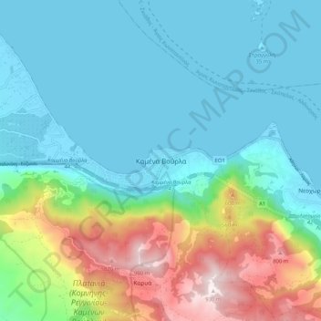
Click on the map to display elevation.
About this map
Name: Kamena Vourla topographic map, elevation, terrain.
Average elevation: 748 ft
Minimum elevation: -16 ft
Maximum elevation: 3,087 ft

Click on the map to display elevation.
Name: Kamena Vourla topographic map, elevation, terrain.
Average elevation: 748 ft
Minimum elevation: -16 ft
Maximum elevation: 3,087 ft