
Quemados topographic map
Interactive map
Click on the map to display elevation.
About this map
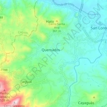
Name: Quemados topographic map, elevation, terrain.
Location: Quemados, San Lorenzo, Puerto Rico, 00754, United States (18.16480 -66.02222 18.18760 -65.95995)
Average elevation: 650 ft
Minimum elevation: 210 ft
Maximum elevation: 2,001 ft
Other topographic maps
Click on a map to view its topography, its elevation and its terrain.
Sector Los Bruseles
United States > Puerto Rico > San Lorenzo
Sector Los Bruseles, Quebrada, San Lorenzo, Puerto Rico, 00778, United States
Average elevation: 436 ft