
Mogadishu topographic map
Interactive map
Click on the map to display elevation.
About this map
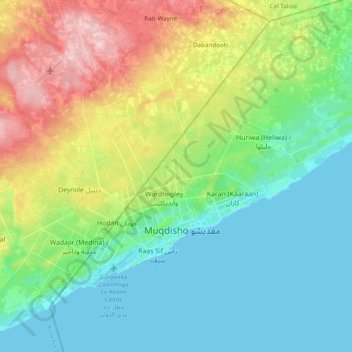
Name: Mogadishu topographic map, elevation, terrain.
Location: Mogadishu, Mogadishu مقديشو, Banaadir, Somalia (2.00349 45.22972 2.12560 45.42304)
Average elevation: 180 ft
Minimum elevation: -3 ft
Maximum elevation: 584 ft
Other topographic maps
Click on a map to view its topography, its elevation and its terrain.