
Ait Melloul topographic map
Interactive map
Click on the map to display elevation.
About this map
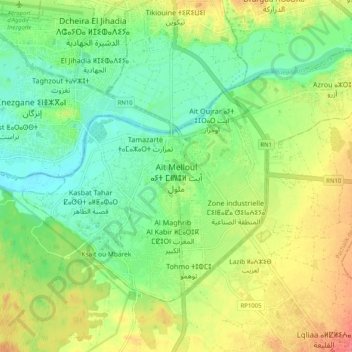
Name: Ait Melloul topographic map, elevation, terrain.
Average elevation: 89 ft
Minimum elevation: 7 ft
Maximum elevation: 207 ft
Other topographic maps
Click on a map to view its topography, its elevation and its terrain.
Agdal
Maroc > Pachalik Ait Meloul > Ait Melloul
Agdal, Ait Melloul, Pachalik Ait Meloul, Préfecture d'Inezgane-Aït Melloul, Souss-Massa, Maroc
Average elevation: 79 ft