
Rodolfo Aguilar Delgado topographic map
Interactive map
Click on the map to display elevation.
About this map
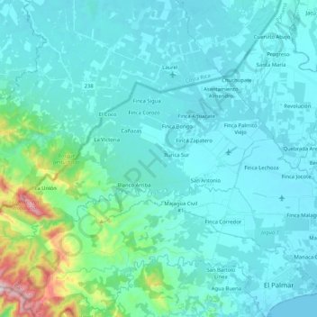
Name: Rodolfo Aguilar Delgado topographic map, elevation, terrain.
Location: Rodolfo Aguilar Delgado, Distrito Barú, Chiriquí, Panamá (8.33303 -83.04791 8.43837 -82.84158)
Average elevation: 282 ft
Minimum elevation: 0 ft
Maximum elevation: 2,320 ft
Other topographic maps
Click on a map to view its topography, its elevation and its terrain.
Buena Vista (Spanish Town)
Panamá > Chiriquí > Distrito Barú > Puerto Armuelles > Monte Verde
Buena Vista (Spanish Town), Monte Verde, Puerto Armuelles, Distrito Barú, Chiriquí, 0406, Panamá
Average elevation: 69 ft
Puerto Armuelles
Panamá > Chiriquí > Distrito Barú
Puerto Armuelles, Distrito Barú, Chiriquí, Panamá
Average elevation: 151 ft
Río Chiriquí Viejo
Panamá > Chiriquí > Distrito Barú > Progreso
Río Chiriquí Viejo, Progreso, Distrito Barú, Chiriquí, Panamá
Average elevation: 62 ft
Charco Azul Bay
Panamá > Chiriquí > Distrito Barú > Rodolfo Aguilar Delgado
Charco Azul Bay, Rodolfo Aguilar Delgado, Distrito Barú, Chiriquí, Panamá
Average elevation: 95 ft