
Make a donation
Gear up for your next adventure:
As an Amazon Associate, this site earns from qualifying purchases at no extra cost to you.
Penglai District topographic map
Click on the map to display elevation.
Make a donation
Gear up for your next adventure:
As an Amazon Associate, this site earns from qualifying purchases at no extra cost to you.
Penglai District
The production of wine is the second largest industry in the province. Agriculture is first. However, in Penglai, tourism is the primary industry, and wine-making is second. The hills south of Penglai have an average elevation of 200 metres (660 ft), while the coastal areas are relatively flat. Most of the soil is loose, well-aerated, and rich in minerals and organic matters that enable full development of the root systems. The wineries are located mainly in the Nanwang Grape Valley and along the Yan-Peng Sightseeing Highway. The main varieties grown there, like Cabernet Sauvignon, Cabernet Gernischt, Merlot, Riesling and Chardonnay, are all reaching 20 years of age, considered to be the golden stage for these grapes. Most of them maintain an average sugar content of above 20%. The Cabernet is especially typical, with good color and a dense fragrance.
Make a donation
Gear up for your next adventure:
As an Amazon Associate, this site earns from qualifying purchases at no extra cost to you.
About this map
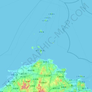
Name: Penglai District topographic map, elevation, terrain.
Location: Penglai District, Yantai City, Shandong, 264000, China (37.41537 120.55057 38.42078 121.08813)
Average elevation: 85 ft
Minimum elevation: -10 ft
Maximum elevation: 2,333 ft
Make a donation
Gear up for your next adventure:
As an Amazon Associate, this site earns from qualifying purchases at no extra cost to you.