
Maadid topographic map
Interactive map
Click on the map to display elevation.
About this map
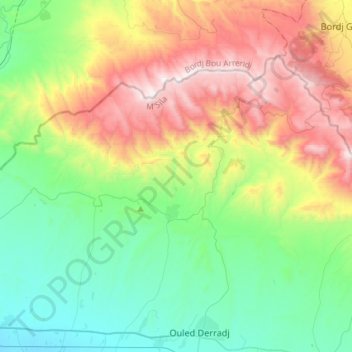
Name: Maadid topographic map, elevation, terrain.
Location: Maadid, Daïra Ouled Derradj, M'Sila, Algérie (35.71672 4.61090 35.87863 4.90273)
Average elevation: 3,064 ft
Minimum elevation: 1,493 ft
Maximum elevation: 6,093 ft
Other topographic maps
Click on a map to view its topography, its elevation and its terrain.
Chott el Hodna
Algérie > M'Sila > Daïra Ouled Derradj
Chott el Hodna, Daïra Ouled Derradj, M'Sila, Algérie
Average elevation: 1,306 ft
Ouled Derradj
Algérie > M'Sila > Daïra Ouled Derradj > Ouled Derradj
Ouled Derradj, Daïra Ouled Derradj, M'Sila, 28022, Algérie
Average elevation: 1,765 ft