
Śródmieście topographic map
Interactive map
Click on the map to display elevation.
About this map
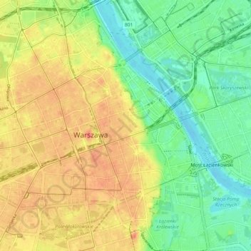
Name: Śródmieście topographic map, elevation, terrain.
Location: Śródmieście, Warsaw, Masovian Voivodeship, Poland (52.20682 20.98103 52.26121 21.06353)
Average elevation: 331 ft
Minimum elevation: 240 ft
Maximum elevation: 433 ft
Other topographic maps
Click on a map to view its topography, its elevation and its terrain.
Warsaw
Poland > Masovian Voivodeship > Warsaw
Warsaw, Masovian Voivodeship, Poland
Average elevation: 312 ft
Warsaw
Poland > Masovian Voivodeship > Warsaw
Warsaw, Masovian Voivodeship, Poland
Average elevation: 315 ft
Żoliborz
Poland > Masovian Voivodeship > Warsaw
Żoliborz, Warsaw, Masovian Voivodeship, Poland
Average elevation: 312 ft
Praga-Południe
Poland > Masovian Voivodeship > Warsaw
Praga-Południe, Warsaw, Warszawa, Masovian Voivodeship, Poland
Average elevation: 282 ft