
Baños de Jesus topographic map
Interactive map
Click on the map to display elevation.
About this map
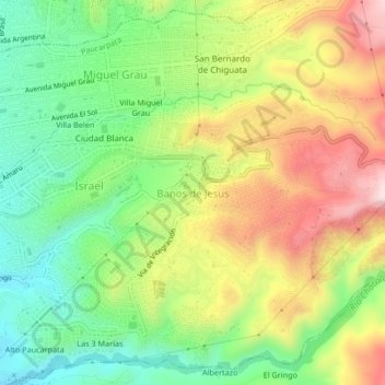
Name: Baños de Jesus topographic map, elevation, terrain.
Location: Baños de Jesus, Paucarpata, Arequipa, 04008, Perú (-16.44028 -71.49478 -16.40028 -71.45478)
Average elevation: 8,596 ft
Minimum elevation: 7,940 ft
Maximum elevation: 9,462 ft
Other topographic maps
Click on a map to view its topography, its elevation and its terrain.
Villa Belen
Perú > Arequipa > Paucarpata > Baños de Jesus
Villa Belen, Baños de Jesus, Paucarpata, Arequipa, 04008, Perú
Average elevation: 8,379 ft