
Arrate topographic map
Interactive map
Click on the map to display elevation.
About this map
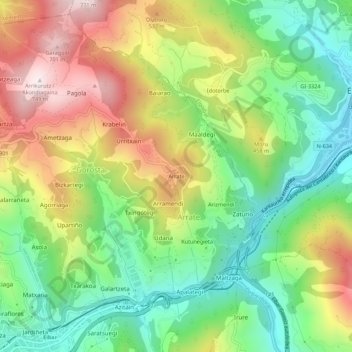
Name: Arrate topographic map, elevation, terrain.
Location: Arrate, Éibar, Bajo Deba, Guipúzcoa, País Vasco, 20600, España (43.18459 -2.46595 43.22459 -2.42595)
Average elevation: 1,089 ft
Minimum elevation: 144 ft
Maximum elevation: 2,428 ft
Other topographic maps
Click on a map to view its topography, its elevation and its terrain.
Egazelai
España > País Vasco > Bajo Deba > Éibar
Egazelai, Ubitxa, Otaola-Kiñarra, Éibar, Bajo Deba, Guipúzcoa, País Vasco, 20600, España
Average elevation: 912 ft
Trango
España > País Vasco > Bajo Deba > Éibar
Trango, Kortalarrañeta, Mandiola, Éibar, Bajo Deba, Guipúzcoa, País Vasco, 20600, España
Average elevation: 1,539 ft
Éibar
España > País Vasco > Bajo Deba > Éibar
Éibar, Bajo Deba, Guipúzcoa, País Vasco, 20600, España
Average elevation: 1,234 ft