
Cajarc topographic map
Interactive map
Click on the map to display elevation.
About this map
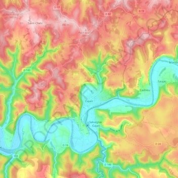
Name: Cajarc topographic map, elevation, terrain.
Average elevation: 902 ft
Minimum elevation: 453 ft
Maximum elevation: 1,299 ft
Other topographic maps
Click on a map to view its topography, its elevation and its terrain.
Réserve naturelle d'intérêt géologique du département du Lot
Frankreich > Okzitanien > Lot > Esclauzels
Réserve naturelle d'intérêt géologique du département du Lot, Esclauzels, Cahors, Lot, Okzitanien, Metropolitanes Frankreich, 46090, Frankreich
Average elevation: 955 ft