
Hazen topographic map
Interactive map
Click on the map to display elevation.
About this map
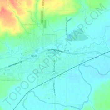
Name: Hazen topographic map, elevation, terrain.
Location: Hazen, Mercer County, North Dakota, 58545, United States (47.29038 -101.64808 47.30945 -101.59805)
Average elevation: 1,765 ft
Minimum elevation: 1,722 ft
Maximum elevation: 1,896 ft
Other topographic maps
Click on a map to view its topography, its elevation and its terrain.
Stanton
United States > North Dakota > Mercer County
Stanton, Mercer County, North Dakota, United States
Average elevation: 1,699 ft
Beulah
United States > North Dakota > Mercer County
Beulah, Mercer County, North Dakota, United States
Average elevation: 1,844 ft