
Las Calderas topographic map
Interactive map
Click on the map to display elevation.
About this map
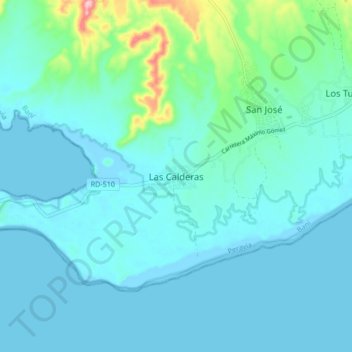
Name: Las Calderas topographic map, elevation, terrain.
Location: Las Calderas, Baní, Peravia, República Dominicana (18.17888 -70.53196 18.25888 -70.45196)
Average elevation: 79 ft
Minimum elevation: -13 ft
Maximum elevation: 584 ft
Other topographic maps
Click on a map to view its topography, its elevation and its terrain.
Baní
República Dominicana > Peravia > Baní
Baní, Peravia, República Dominicana
Average elevation: 489 ft
Las Salinas
República Dominicana > Peravia > Baní
Las Salinas, Baní, Peravia, República Dominicana
Average elevation: 13 ft