
Landreville topographic map
Interactive map
Click on the map to display elevation.
About this map
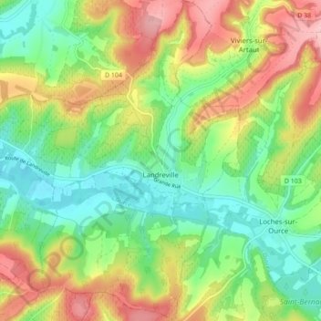
Name: Landreville topographic map, elevation, terrain.
Average elevation: 761 ft
Minimum elevation: 531 ft
Maximum elevation: 1,102 ft
Other topographic maps
Click on a map to view its topography, its elevation and its terrain.
Vallentigny
Vallentigny, Bar-sur-Aube, Aube, Grand Est, Metropolitan France, 10500, France
Average elevation: 407 ft
Droupt-Saint-Basle
Droupt-Saint-Basle, Nogent-sur-Seine, Aube, Grand Est, Metropolitan France, 10170, France
Average elevation: 308 ft
Dolancourt
Dolancourt, Bar-sur-Aube, Aube, Grand Est, Metropolitan France, 10200, France
Average elevation: 646 ft
Étang de la Barrière
France > Grand Est > Aube > Vallentigny
Étang de la Barrière, Vallentigny, Bar-sur-Aube, Aube, Grand Est, Metropolitan France, 10500, France
Average elevation: 433 ft
Linçon
France > Grand Est > Aube > Saint-Germain
Linçon, Saint-Germain, Troyes, Aube, Grand Est, Metropolitan France, 10120, France
Average elevation: 417 ft
Les Granges
France > Grand Est > Aube > Les Granges
Les Granges, Troyes, Aube, Grand Est, Metropolitan France, 10210, France
Average elevation: 472 ft