
临淄区 topographic map
Interactive map
Click on the map to display elevation.
About this map
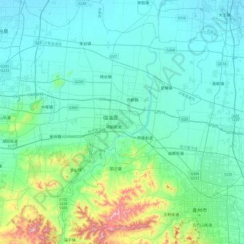
Name: 临淄区 topographic map, elevation, terrain.
Location: 临淄区, 淄博市, 山东省, 255438, 中国 (36.63131 118.12460 37.00544 118.49128)
Average elevation: 305 ft
Minimum elevation: 36 ft
Maximum elevation: 1,791 ft
Other topographic maps
Click on a map to view its topography, its elevation and its terrain.