
Mebane topographic map
Click on the map to display elevation.
About this map
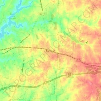
Name: Mebane topographic map, elevation, terrain.
Location: Mebane, Alamance County, North Carolina, United States (36.05721 -79.31985 36.13532 -79.22415)
Average elevation: 643 ft
Minimum elevation: 518 ft
Maximum elevation: 745 ft
Alamance County trails, hiking, mountain biking, running and outdoor activities
Other topographic maps
Click on a map to view its topography, its elevation and its terrain.
Wedgewood West
United States > North Carolina > Alamance County > Burlington
Average elevation: 666 ft
Country Club Estates
United States > North Carolina > Alamance County > Burlington
Average elevation: 640 ft