
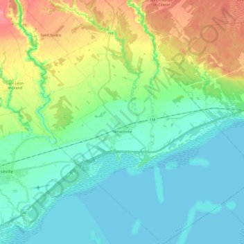
Yamachiche topographic map
Interactive map
Click on the map to display elevation.
About this map
Name: Yamachiche topographic map, elevation, terrain.
Average elevation: 72 ft
Minimum elevation: 3 ft
Maximum elevation: 236 ft
Other topographic maps
Click on a map to view its topography, its elevation and its terrain.
Lac Lise
Canada > Quebec > Maskinongé (MRC) > Saint-Alexis-des-Monts
Lac Lise, Saint-Alexis-des-Monts, Maskinongé (MRC), Mauricie, Quebec, Canada
Average elevation: 1,276 ft
Louiseville
Canada > Quebec > Maskinongé (MRC)
Louiseville, Maskinongé (MRC), Mauricie, Quebec, Canada
Average elevation: 56 ft
Saint-Boniface
Canada > Quebec > Maskinongé (MRC)
Saint-Boniface, Maskinongé (MRC), Mauricie, Quebec, G0X 2L0, Canada
Average elevation: 482 ft