
Bärndorf topographic map
Interactive map
Click on the map to display elevation.
About this map
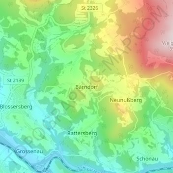
Name: Bärndorf topographic map, elevation, terrain.
Average elevation: 1,867 ft
Minimum elevation: 1,329 ft
Maximum elevation: 2,940 ft
Other topographic maps
Click on a map to view its topography, its elevation and its terrain.
Blossersberg
Deutschland > Bayern > Landkreis Regen > Viechtach
Blossersberg, Viechtach, Landkreis Regen, Bayern, 94234, Deutschland
Average elevation: 1,588 ft
Eben
Deutschland > Bayern > Landkreis Regen > Viechtach > Pirka
Eben, Pirka, Viechtach, Landkreis Regen, Bayern, 94234, Deutschland
Average elevation: 1,854 ft