
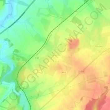
Lécourt topographic map
Interactive map
Click on the map to display elevation.
About this map
Name: Lécourt topographic map, elevation, terrain.
Average elevation: 1,198 ft
Minimum elevation: 1,073 ft
Maximum elevation: 1,322 ft
Other topographic maps
Click on a map to view its topography, its elevation and its terrain.
Ravennefontaines
France > Grand Est > Haute-Marne > Val-de-Meuse
Ravennefontaines, Val-de-Meuse, Langres, Haute-Marne, Grand Est, France métropolitaine, France
Average elevation: 1,230 ft
Montigny le Roi
France > Grand Est > Haute-Marne > Val-de-Meuse
Montigny le Roi, Val-de-Meuse, Langres, Haute-Marne, Grand Est, France métropolitaine, 52140, France
Average elevation: 1,257 ft