Geolocate

Santorini topographic map

Click on the map to display elevation.

About this map

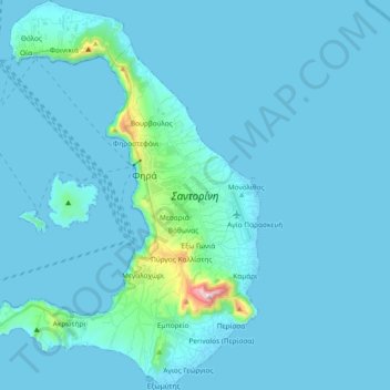
Name: Santorini topographic map, elevation, terrain.

Location: Santorini, Thira Municipal Unit, Municipality of Thira, Thira Regional Unit, South Aegean, Aegean, Greece (36.33217 25.35386 36.48221 25.48789)

Average elevation: 98 ft

Minimum elevation: -3 ft

Maximum elevation: 1,808 ft

Other topographic maps

Click on a map to view its topography, its elevation and its terrain.

Gear up for your next adventure:

🥇GPS Hiking Watch - Multi‑sport GPS watch with navigation and trail tracking
🧯Portable Fire Pit - Compact fire pit for camping spots
🔪Outdoor Multitools - Essential survival tools for gear repair and field use
🧢Outdoor Hiking Hat - Sun protection hat for outdoor explorers
🪶Trail Camera - Capture wildlife on your hikes

As an Amazon Associate, this site earns from qualifying purchases at no extra cost to you.