
Ivy Island topographic map
Interactive map
Click on the map to display elevation.
About this map
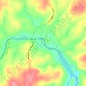
Name: Ivy Island topographic map, elevation, terrain.
Location: Ivy Island, Talbot County, Georgia, USA (32.83630 -84.42155 32.83831 -84.42019)
Average elevation: 591 ft
Minimum elevation: 440 ft
Maximum elevation: 745 ft
Other topographic maps
Click on a map to view its topography, its elevation and its terrain.
Ferrell Crossroads
USA > Georgia > Ferrell Crossroads
Ferrell Crossroads, Early County, Georgia, USA
Average elevation: 308 ft
Cameron Point
USA > Georgia > Cameron Point
Cameron Point, Hall County, Georgia, 30506:30534, USA
Average elevation: 1,112 ft