
Nájera topographic map
Interactive map
Click on the map to display elevation.
About this map
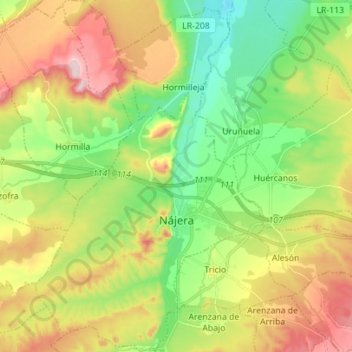
Name: Nájera topographic map, elevation, terrain.
Location: Nájera, La Rioja, 26300, España (42.37796 -2.78970 42.48067 -2.65066)
Average elevation: 1,788 ft
Minimum elevation: 1,421 ft
Maximum elevation: 2,316 ft
Other topographic maps
Click on a map to view its topography, its elevation and its terrain.
Albelda de Iregua
Albelda de Iregua, La Rioja, 26120, España
Average elevation: 2,018 ft
El Mediano
El Mediano, Varea, Logroño, La Rioja, 26009, España
Average elevation: 1,220 ft
Mansilla de la Sierra
España > La Rioja > Mansilla de la Sierra
Mansilla de la Sierra, La Rioja, España
Average elevation: 4,656 ft
El Señorío
El Señorío, Alfaro, La Rioja, 31591, España
Average elevation: 1,030 ft