
Tso Moriri topographic map
Interactive map
Click on the map to display elevation.
About this map
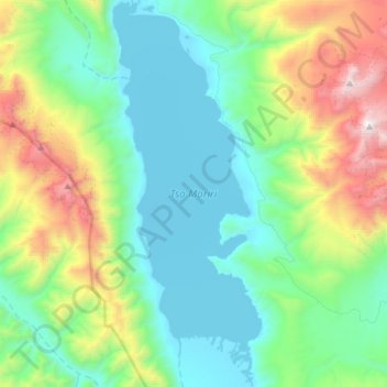
Name: Tso Moriri topographic map, elevation, terrain.
Location: Tso Moriri, Karzok, Leh Tehsil, Leh district, Ladakh, India (32.76360 78.25919 33.01494 78.37442)
Average elevation: 16,549 ft
Minimum elevation: 14,816 ft
Maximum elevation: 21,841 ft
Other topographic maps
Click on a map to view its topography, its elevation and its terrain.
Karzok
India > Ladakh > Leh Tehsil > Karzok
Karzok, Leh Tehsil, Leh district, Ladakh, India
Average elevation: 15,151 ft